Puerto Varas to Villa O Higgins
Carretera Austral 1.240 km
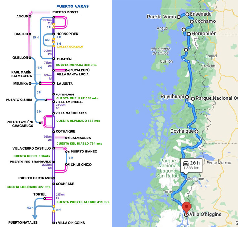
* This map of the Carretera Austral was originally designed by Cicleayque.
SUGGESTED ITINERARY – From North to South
Puerto Varas to Villa O Higgins.
** We strongly believe that if you love trekking, kayaking, fishing and other outdoor activities, you will be very happy to have some extra days on your itinerary.
THAT´S WHY WE SUGGEST TO SPEND 30 DAYS AT LEAST ON CARRETERA AUSTRAL.
Arrival at Tepual Airport
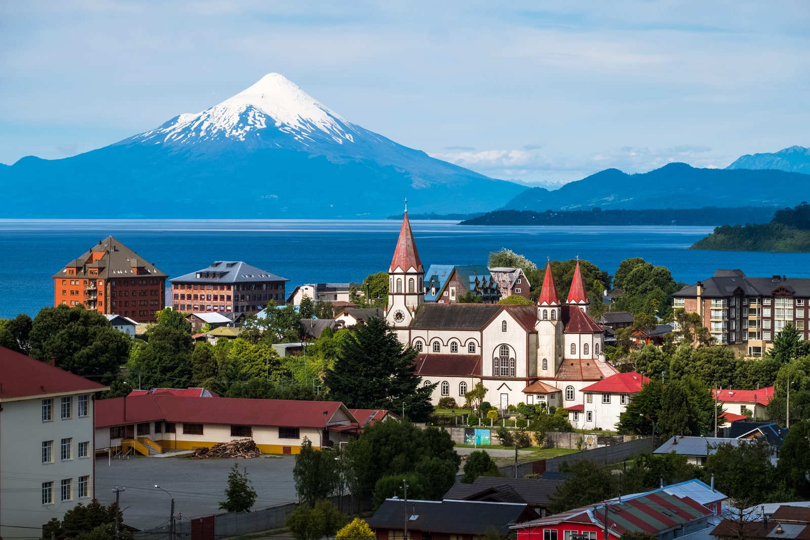
Day 1Puerto Varas - Ensenada 45 km
Day 2Ensenada - Cochamó 48,2 km
Day 3Cochamó - Contao 77,6 km
Day 4Contao - Hornopirén 45,1 km
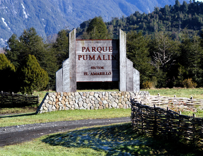
Day 5Hornopirén - Caleta Gonzalo/ Pumalín National Park 80 km
Day 6Pumalín Park - Yelcho Lake. 65 kms
Day 7Yelcho Lake - La Junta 82 kms
Day 8La Junta - Puyuhuapi 45,4 kms
Day 9Puyuhuapi - Queulat National Park 25 kms
Day 10Queulat National Park - Villa Amengual 66,3 kms
Day 11Villa Amengual - Villa Mañihuales 58,1 kms
Day 12Villa Mañihuales - Coyhaique 87 kms
Day 13Coyhaique - Villa Cerro Castillo
Day 14Villa Cerro Castillo - Murta River Valley
Day 15Murta River Valley - Puerto Rio Tranquilo
Day 16Puerto Rio Tranquilo - Puerto Bertrand
Day 17Puerto Bertrand - Cochrane
Day 18Cochrane - Los Ñadis
Day 19Los Ñadis - Caleta Tortel
Day 20Caleta Tortel - Río Bravo
Day 21Rio Bravo - Villa O Higgins - BIKE DROPOFF
Day 22Villa O Higgins - Cochrane BUS
Day 23Cochrane - Coyhaique BUS
Day 24Coyhayque - to Puerto Montt- Return Home BUS
Day 25RETURN HOME- Tepual Airport
Day 26*If you like trekking, fishing, kayaking or feel adventurous we suggest taking some extra days
Day 27-30BICYCLE RENTAL
ONE MONTH RENTAL: USD 570.-
DROPOFF VILLA O HIGGINS: USD 170.
NEED LODGING?
Please, write us a message: info@australbikes.cl if you need help with some bookings, although we advise that only for your first and final dates.
It´s very risky to do that for other days, as you may need more days to explore while on your journey, or the road might be closed for one or two days due to climate: rain, snow or river floods.
Total distance: 1.240 km.
Total days: 30
Difficulty: Medium / High
Road type: 80% pavement – 20% gravel.
self guided tour
included
_________________________________________________
– IF YOU WANT TO BOOK LODGING:
We can help booking your B&B, Hostel, Cabin – Twin or Double Bed Rooms.
Breakfast and Dinner: can be included in some of the B&B, Lodges, Hotels, Cabins and Hosteles.
– IF YOU NEED CAMPING GEAR:
A tent, a sleeping bag, a matt, a camping stove, camping pots, 2 x 230 cc gas for the stove, a lantern and cuttlery.
_________________________________________________
Bike rental: 30 days included. Excellent quality bikes, Merida brand, specially selected for the trails of the zone and the gravel road on Carretera Austral (easily handleable).
Bike Pickup at Puerto Varas
Bike Dropoff at Villa O Higgins.
All of our services include: Topeak Explorer Rear Racks, Ortlieb waterproof panniers 40 lts (20 lts each side), handlebar bag (15 lts), mini-triangular frame bag, Gyro helmets, bottle cage, lock, lights, spare tubes, multi tools, tyre levers, allen wrench set, pump, chain cutter, quick link, patches, glue and reflective vests.
Phone assistance
not included
Airport transfer to Puerto Varas: arrival from Tepual Airport – Puerto Montt.
Bus Returning from Villa O Higgins to Cochrane and bus returning from Cochrane to Coyhaique.
– Bus/Air Flight Tickets Returning from Coyhaique to Puerto Montt.
– Tickets for any of the ferries.
– Airport transfer to El Tepual Airport in Puerto Montt: Return to Santiago.
– Guide
– All that´s not mentioned above as included.
make your reservation


ITINERARY:
Although Carretera Austral starts officially in Puerto Montt, we advise you to start from Puerto Varas, Ensenada, Cochamó, Puelo and Contao, because it´s a beautiful place, that you will miss if starting from Puerto Montt.
DAY 1 – Arrival at Tepual Airport
The nearest Airport is El Tepual (PMC) in Puerto Montt. All domestic flights are operated by three local airline companies: Latam, Sky Airlines and JetSmart. Its very easy to get transport to Puerto Varas. Two good transfer companies at Tepual´s Airport are Turis Tour or Survip.
They offer regular and private shuttles to Puerto Varas at $30.000 CLP.
Day 2 – Puerto Varas – Ensenada: After arriving to Ensenada, you can leave your bags at the hostel and visit Saltos de Petrohué ** remember to secure the bike with the lock that we have provided to you, and you can also visit Lake Todos los Santos (if you are not too tired).
Day 3 – Ensenada – Cochamó: Cochamó has been called the Yosemite of Chile, the Valley is beyond comparison, the granite cliffs rise one thousand meters from the valley floor, here are also a bunch of day hikes, as well as multi-day adventures that you can access from Cochamo Valley.
Day 5- Contao – Hornopirén: As you continue South, the density of the forests will increase considerably and inversely the towns and houses will decrease.. After Contao, the supplys offered will be mostly bread. Hualaihué, Caleta Manzano and Pichicolo are good options to have lunch or find some more supplies, you can also chose to buy supplies in Hornopirén where there are supermarkets, stores and restaurants. At Hornopirén you will find the office of Naviera Austral: you can buy tickets for the Bimodal Ferry that will allow you to continue to Caleta Gonzalo in Pumalín Park.
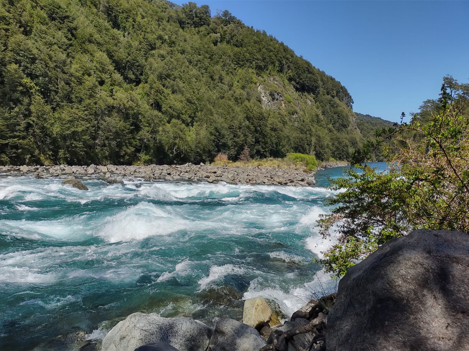
Day 7 – Pumalin Park – Yelcho Lake: Pumalin Douglas Tompkins National Park is a stunning area that offers some great opportunities for outdoor lovers, beautiful hiking trails and in-nature campsites. The scenery in Pumalin is truly spectacular: crystal clear rivers, lush green forest, unique flora and fauna. Lake Yelcho is well known for its emerald green waters and for being an excellent place for sport fishing.
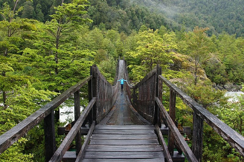
It is surrounded by high mountains and a lush vegetation of evergreen temperate Patagonian rain forest. Where the Yelcho River is born, in Puerto Cardenas is located one of the landmarks of the Carretera Austral, a suspension bridge 250 meters long built in 1989, the first of its kind in the country. This bridge made it possible to connect almost unexplored territories to the south of the Carretera Austral and unite the Aysen Region with the Los Lagos Region.
Day 8 – Puerto Cardenas: Puerto Cardenas is home to an impressive selection of attractions and experiences, making it well worth a visit.
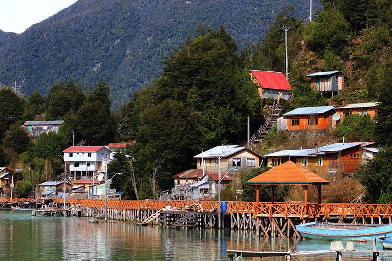
Day 9 – Puyuhuapi:
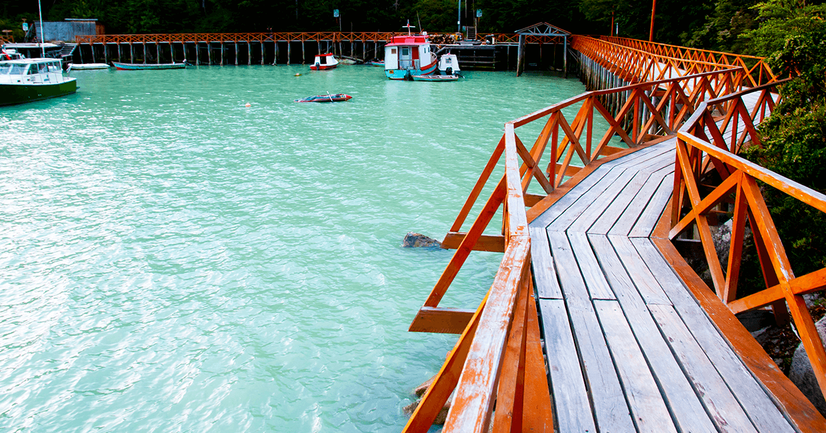
Puyuhuapi is a quiet and peaceful village located at the far end of a fjord, surrounded by hills and mountains covered with thick green vegetation. German immigrants founded it in 1935 and their influence can still be noticed in the local architecture and cuisine. Stroll through this tiny village and admire the local houses, the church, the beauty of the fjord with the clouds drifting over the water in the morning and the colourful fishing boats.
Four species of dolphins play in the waters of Puyuhuapi. Take a kayak or boat tour to observe the wonderful fjord and these amazing creatures.
Don’t miss out on the many activities in the area:
The southern part of the Carretera Austral gets more remote the farther south you go, and the landscape just keeps getting more and more stunning.
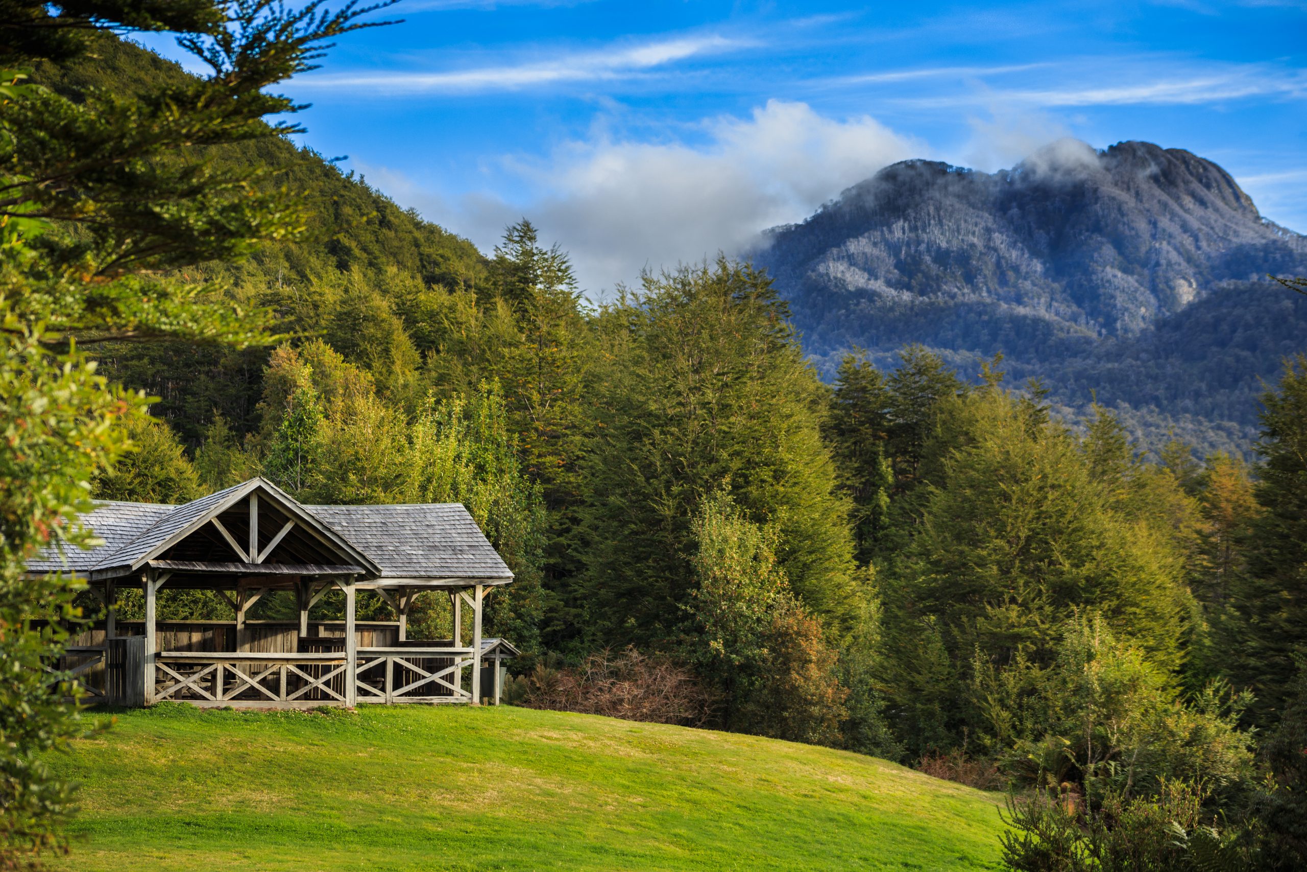
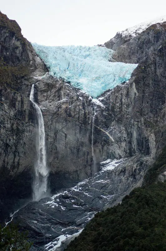
Day 10- Puyuhuapi – Queulat National Park: You will arrive to Queulat after two hours of cycling, we have designed this on purpose, so you can spend the rest of the day walking the trails or taking an excursion. Don’t miss out on the Queulat National Park (entrance 24 km south of Puyuhuapi) with rivers winding through its fairy tale lush wilderness. The most popular route is the 3,2 km hike to the famous hanging glacier or “Ventisquero Colgante” where you can see and hear the ice crashing down on the rocks. In summer you can take it easy and hop on one of the small boats that navigate you across the Laguna Témpanos to the glacier.
51km south of Puyuhuapi is the Bosque Encantado (Enchanted Forest), a moist, magical forest where gremlins and elves must live. An hour’s walk
takes you to where the glacial waterfalls drop into the river.
Take all your wet weather gear.
Day 14: Villa Cerro Castillo
This town is named after the magnificent Castillo peak and is located in the Ibáñez River Valley, 59 miles south of Coyhaique. Cerro Castillo is known for its striking landscapes made up of hanging glaciers, turquoise-colored lakes, and beautiful Lenga forests, the perfect home for Huemules (South Andean Deer).
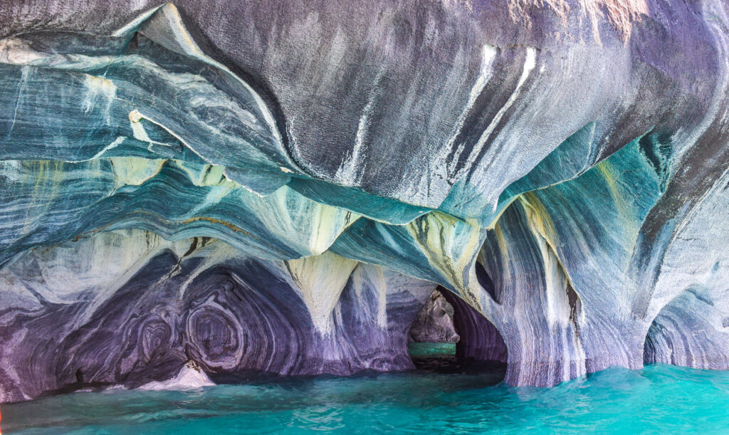
Day 17: The Marble Caves
The Marble Caves (also called the Capillas de Mármol) is one of the best-hidden gems in Chile’s Patagonia region, those bucket list spots that are well worth a trip.
They are located on General Carrera Lake and can be only accessed by boat or kayak. The magnificent Marble Caves have formed over the last 6000+ years as the water melted from the nearby glaciers filling up General Carrera Lake and washing up against these solid rocks slowly carving out intricate caverns, columns, and tunnel systems.
Day 18: The beautiful town of Puerto Bertrand:
This is the perfect place to do rafting and kayaking on Lake Bertrand, and then arrive at the confluence from the Nef River with the mightiest river in Chile, the Baker River.
Day 18: Cochrane: Was founded in 1954 as Pueblo Nuevo, later changed to Cochrane to honor Thomas Cochrane, 10th Earl of Dundonald a British Naval Captainand politician who was appointed as the First Admiral of the Chilean Navy who made a mayor contribution winning Chilean Independance from Spain.
Day 20: Caleta Tortel
Built almost entirely from wood, it is a labyrinthine maze connected by sturdy boardwalks that snake down the mountainside, and branch out along the bay. Houses appear to be piled on top of each other, and wild mosses, lichens and ferns blanket the landscape. Walk the 15 kilometres of boardwalks along the milky-blue Tortel bay and immerse yourself in Aysen culture in traditional lodging and restaurants.
Day 22-23: Villa O’Higgins: Marks the end of the Carretera Austral and the beginning of Chile’s Southern Ice Fields. The town is located in the midst of a gorgeous, pristine, and remote landscape, at the mouth of the Mayer River and the O’Higgins Lake, which is the deepest lake on the American continent at 2743 feet deep. The lake was formed by the O’Higgins Glacier.
The first settlers arrived in 1914, but the town wasn’t incorporated until 1966. It was named in honor of Chilean independence leader Bernardo O’Higgins.
BEFORE YOU HIT THE ROAD
Pack enough food and water: Double-check that you´ve got everything you may need!
Be sure to carry enough cash money: Remember that you´ll need to find the next ATM machine. Although there are now plenty of ATM´s along the Carretera Austral, the rule of thumb is to check you have enough to pay for food and lodging as in most places it will be impossible to pay with debit or credit cards.
Pick up a copy of the COPEC – Map Chiletur Copec Area 7- Carretera Austral: This map is indispensable for anyone cycling in Carretera Austral. You can buy it at our store, or in any COPEC gas station for around $4,900 CLP.
Download Maps.me before you set off: This free app allows you to download maps of the Carretera Austral to your phone (do this while you still have a wifi connection) that can then be used offline.
Download the ioverlander app: This free app is a guide to road conditions and campsites as compiled by people who travel. It is an indispensable resource for helping you to find good wild camping spots, as well as up-to-date information about the state of the Carretera Austral. You do need internet to be able to access the maps in the app.
A local sim card: Entel provides the best coverage along the Carretera Austral. If you plan on booking accommodations and doing other logistical stuff en-route, don’t expect to be able to rely on the internet along the Carretera Austral. The internet reception might be very poor, not all hostels or cabins have WIFI, so sort this. Entel, Movistar, Claro and Wom may not have coverage everywhere.
Carretera Austral remains a work in progress, unpaved at some points and impassable due to the rain, snow and wind: qualities that have helped secure the Carretera Austral as one of South America’s most remote and beguiling road trips. The road works can cause sections of the road to be closed, this information is best found by consulting the tourism office of the town you’re in and then planning accordingly.
Pack the right clothing for hot and cold weather: Clothes that can be layered up in cold weather and stripped down in warm weather are versatile for any temperature.
A water bottle and water filter: Water is potable in Carretera Austral, however, if you have a sensitive stomach, it’s best to err on the side of caution.
Toilet paper: Public toilets are few and far between! Be sure to come prepared instead.
Camping: There are many campsites along the route and is generally permissible to set your tent where ever you want along the Carretera Austral, your common sense will give you a right idea where you can’t and where it’s recommendable to stay, anyway, remember you will be staying on wild and pristine areas, so practice leaving no trace principles and make sure that you won´t leave any rubbish. If the land is clearly privately owned and there’s a dwelling nearby, be sure to pop in and ask for permission before settling down for the night.